Category: Victoria – Urban Forest
-
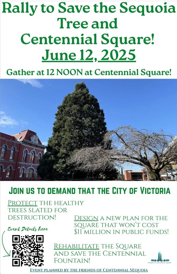
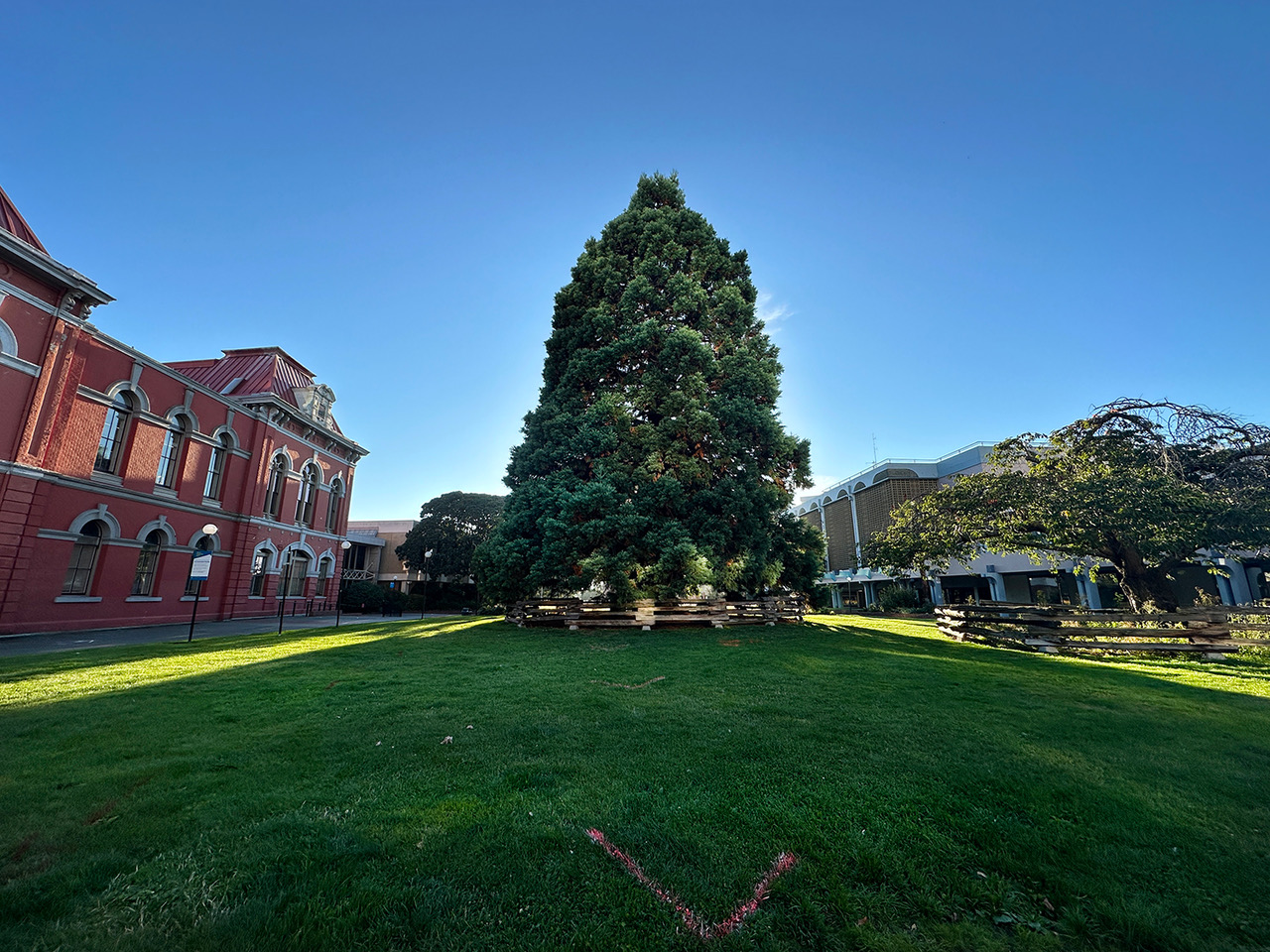
A Rally to Save the Centennial Sequoia. June 12th at 12 noon (lunchtime rally) at Centennial Square, City of Victoria Municipal Hall
The inaugural event attended by Squirrel for Mayor was at “A Rally to Save the Centennial Sequoia,” planned by “Friends of Centennial Square,” a group of residents from the City of Victoria. The rally was aimed at protesting the City Council’s decision to remove a mature sequoia tree to facilitate a redesign of the square. Over time, the Sequoia Read more
-
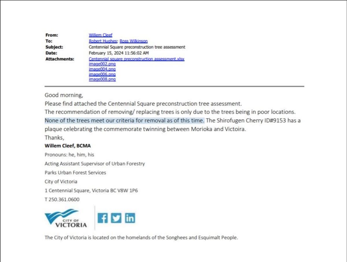
A Freedom of Information response revealed that City of Victoria staff stated in February 2024 that none of the trees in Centennial Square met the criteria for removal.
Originally posted at CRD WATCH A Freedom of Information response revealed that City of Victoria staff stated in February 2024 that none of the trees in Centennial Square met the criteria for removal.The document provides compelling evidence that counters later claims by City of Victoria councillors that the trees are unsafe. The document also underscores Read more
-
Climate funding Victoria’s Centennial Square and the Sequoia tree.
At the January 23rd Council of the Whole Meeting, Councillor Matt Dell shared his experiences of tree removal and replacement regarding the need to advance a city, thus emphasizing the need for context in urban planning. “I grew up in a farming family in the South Okanagan, where trees are cut down and replanted every Read more
-
Council Member Motion – Urban Forest Canopy
Council Member MotionFor the Committee of the Whole Meeting of April 3rd, 2025 COTW Video segment:https://pub-victoria.escribemeetings.com/Meeting.aspx?Id=f613a2e9-ce96-43b6-aca8-b281afcdaf54&Agenda=Merged&lang=English&Item=23&Tab=attachments Motion (.pdf)https://pub-victoria.escribemeetings.com/filestream.ashx?DocumentId=101687 BACKGROUND: A significant value for Victorians is nature, our climate, our hills, our natural green areas, and our urban forest. Section 4, Blue Green Networks of the 2025 DRAFT OCP, includes a brief description of the City’s Read more
-
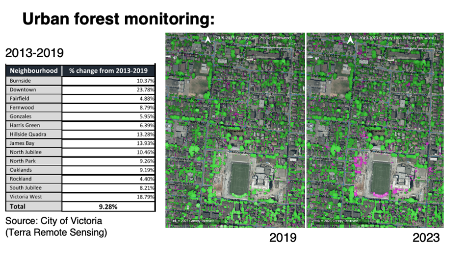
City of Victoria’s 2019-2023 LiDAR vegetation change detection analysis
City of Victoria Tree Canopy Using LiDAR data to Measure the City’s Tree Canopy. LiDAR (Light Detection and Ranging) technology uses laser pulses to create detailed 3D models of the environment. The City of Victoria’s Urban Forest Canopy Analysis from 2019 to 2023 was posted on Wednesday, April 02, 2025. Individual data points create point Read more
-
Presentation to Council- Urban Forest and Natural Assets, City of Victoria
Presentation: Thursday, March 13, 2025 at 6:30 P.M. Council Chambers E. Request to Address Council E.7 Urban Forest and Natural Assets (LiDAR) update for Draft OCP “Victoria 2050” Video Link: https://pub-victoria.escribemeetings.com/Meeting.aspx?Id=22a0de46-6b14-4887-83fe-114fa79ced8d&Agenda=Merged&lang=English&Item=29&Tab=attachments Documents: The City of Victoria has collected urban tree canopy data over multiple years by to perform ongoing measurements of its urban forest canopy. The City has outsourced urban tree canopy monitoring Read more
-
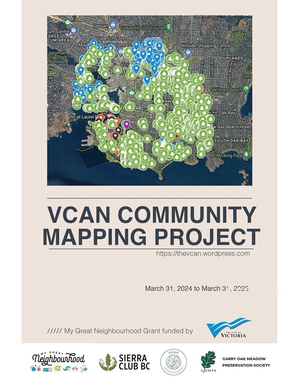
VCAN Community Mapping Project
A conversation about the distribution of biodiversity within and between the City of Victoria’s neighbourhoods. To complement the City’s excellent inventory of all trees on public land, the Victoria Community Association Network (VCAN) has involved each neighbourhood in an inventory of Garry oaks and other elements of biodiversity on private property. Each neighbourhood developed their Read more
-
Open Letter to Matt Dell and City of Victoria Councillors about the Urban Forest
Dear Councillor Matt Dell, This letter serves as an open invitation for you to consider some of the unique community forest qualities in the territory that you now call home. The urban landscape of Victoria is characterized by Kwetlal, known also as the Garry oak ecosystem (GOE). This is a crucial detail often overlooked in Read more
-
City of Victoria 2013 and 2019 Tree Canopy Estimates by Neighbourhood
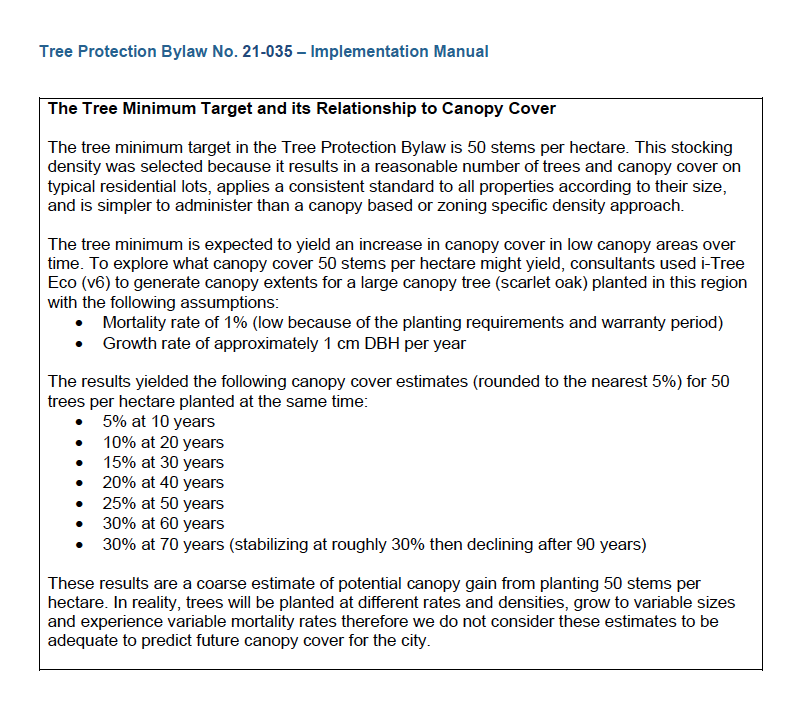
CITY OF VICTORIA 2019 TREE CANOPY ESTIMATES BY NEIGHBOURHOOD Neighbourhood Neighbourhood Area (Ha) 2019 Tree Cover (Ha) Percent of city-wide canopy Burnside 237 34 6% Downtown 77 7 1% Fairfield 297 92 17% Fernwood 175 56 10% Gonzales 136 53 9% Harris Green 24 4 1% Hillside/Quadra 166 57 10% James Bay 236 63 11% Read more